The forest fire situation in northeastern Ontario intensified Thursday as fire officials reported eight new confirmed fires in the northeast region.
The news comes as a restricted fire zone was implemented for much of northern Ontario with restrictions in place until further notice.
The new fires are in the Cochrane, Kirkland Lake and Chapleau areas and all but one appear for now to be 2 hectares or less. (Chapleau 3 meaures 20 hectares.)
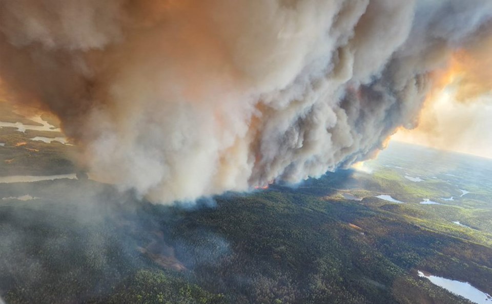
Fires of note remain Wawa 3, which began on May 27, is not yet under control and now measures 6,810 hectares, according to the Ministry of Natural Resources’ fire services division.
The fire is about 9 km southeast of White River along Highway 17 by the Depew River.
There are five helicopters and 12 fire ranger crews assigned to Wawa 3 and additional resources have been requested, Aviation, Forest Fire and Emergency Services for the Northeast Fire Region said in Thursday’s fire situation update.
Fixed-wing fire suppression aircraft (water bombers) have been actively working on priority areas of the fire, it said. Bucketing helicopters and service and transport helicopters are also working on the fire, AFFES said.
The other notable fires were Timmins 6, which began May 31, is 8.5 hectares and not yet under control. The fire is about 13 km west of Timmins and about 5 km north of Highway 101. There are 5 fire ranger crews working on the fire, along with aerial fire suppression.
Finally Wawa 2, which began on May 26, remains at 105 hectares and is not yet under control.
The fires have resulted in a deterioration in air quality for communities to the northeast, with Environment Canada issuing an advisory yesterday for those who may be at risk due to age or health status.
Today’s new confirmed fires include:
- Hearst 3, which is 1.5 hectares and not yet under control. The fire is about 11.5 km southeast of Hearst and 7 km south of Highway 11. A crew is working on the fire along with aerial suppression and “making good progress”, AFFES reported.
- Cochrane 2 is 0.1 hectares and not yet under control. The fire about 7.5 km southeast of Cochrane and 2.5 km south of Highway 652.
- Cochrane 3 is 1 hectare and not yet under control. It’s about 18.5 km south of Cochrane and 10 km west of Highway 11.
- Cochrane 4 is 0.2 hectares and not yet under control, burning about 13 km south of Cochrane and 4.5 km east of Highway 11. (Officials said the Cochrane fires are all located between Cochrane and Iroquois Falls, and crews are seeing heavy smoke and lots of fire activity. Crews are working on the fires and waterbombers are attempting aerial suppression efforts.)
- Kirkland Lake 2 started May 31, is 2 hectares and is being held. It’s about 13.5 km west of Kirkland Lake and 2.5 km northeast of Kenogami Lake.
- Kirkland Lake 3 is 2 hectares and being held. It’s about 28 km northwest of Kirkland Lake and 1.3 km east of Malloch Lake. Crews are working on these fires, along with aerial suppression, and reported to be “making good effort”.
- Chapleau 2 is 0.1 hectares and not yet under control. It’s about 6.3 km southeast of Chapleau and 1 km north of Earl Lake. This small fire has one fire ranger crew and has noted no issues.
- Chapleau 3 is 20 hectares and not yet under control. The fire is about 72 km east of Chapleau and 7.3 km east of Garnet Lake. Fire rangers are on site working on fire suppression.
Sudbury 5, which started May 31, is 1 hectare and is under control, it was reported today. This fire is about 1.5 km east of Clara Belle Lake and there are no noted concerns with this fire.
Due to the fire hazard, travel restrictions were also implemented today by the MNRF Chapleau-Wawa District under an emergency order. The restrictions apply around Mink Lake, Picnic Lake and other areas.
They are outlined on the Implementation Order Map, and are now in effect until further notice.
For a closer look at fire hazard conditions in your area, view this Interactive Map.