For many people, the best sign of winter has little to do with a calendar and snowfall, just mostly with our lakes and rivers freezing.
But the changing climate is affecting even that.
John Dunsmore, who’s been tracking temperatures and precipitation for Environmental (and Climate Change) Canada for 50 years at his Shanty Bay weather station, says the evidence of climate change is irrefutable on area ice.
“It used to freeze between Christmas and New Year’s,” he told BarrieToday of Lake Simcoe and Kempenfelt Bay. “We used to count on a January thaw where there’d be a couple of mild days in January, and then it would get cold again.”
Dunsmore said there was an unusual amount of rain in December and January looks the same, which is hardly conducive to ice.
“We’ve had more rain than snow in January,” he said. “Years ago, the rain gauge was put away for the winter. Not now.”
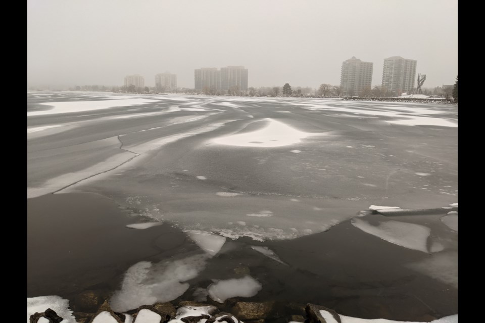
And the milder, wetter weather has naturally affected the freeze-up on Lake Simcoe and Kempenfelt Bay.
What’s required for the freeze-up?
Gerald Cheng, meteorologist with Environment and Climate Change Canada, says a prolonged period of sub-zero temperatures is needed to achieve full ice on a lake.
And what’s full ice?
The Farmer’s Almanac says three inches of solid, clear, blue or black pond or lake ice is safe for a single person, on foot.
A group of people walking in a straight line needs four inches, a car requires 7.5 inches, a light truck eight inches, and 10 inches of ice are needed for a medium-sized truck.
But slushy ice has only half the strength of solid ice.
How has the ice freeze on Kempenfelt Bay changed at the First Concession of Oro-Medonte Township, north of Barrie, where Dunsmore takes his readings?
His numbers from 1973-74 until 1991-92 show a frozen lake for at least 90 days every year, and more than 100 days in 16 of those 19 years.
During the 28 years from 1995 to 2022, only eight years had 100-plus days of ice. The shortest duration was 62 days in 2021.
The ice was in for 94 days in 2022, beginning Jan. 10 and ending April 13.
In simple terms, Dunsmore considers the ice in when it’s solid enough to walk on, or not drive a boat through, and open water when the ice goes out.
Dunsmore said he doesn’t do weather forecasts, for all the data he’s accumulated, but he knows the consequences.
“The freeze-up date’s been getting later every year and the breakup is earlier,” he said. “I don’t think the year is too far away when the lake here isn’t going to freeze over, and we’re not going to have that twice annual turnover of the water.”
Brian Ginn, who's a limnologist (the study of inland aquatic ecosystems) with Lake Simcoe Region Conservation Authority, explains it this way: “Lake turnover, or overturn, is the period when the water column is fully mixed from surface to bottom,” said Ginn, who is known as the 'Lake Doctor'. “In most of our lakes, although there are exceptions, it happens twice a year.
“In spring after ice-off and before the water column stratifies into a warm and cold layer. It also happens in fall when the surface water cools to a temperature close to that in the bottom water and wind mixes the water column,” he added. “The fully mixed water column allows oxygen to return to the bottom water and nutrients to return to the surface.”
Dunsmore also points to the wind for our warmer temperatures, which he says came from the northwest before 2000, but now comes from the south.
“There’s more measurable winds from the southern quadrant than from the other three quadrants put together,” he said. “This is why we’re getting all this warm weather, it’s as simple as that.”
In case you're wondering, Environment Canada is calling for a bit of winter today, minus-5 Celsius and snow, followed by minus-5 C on Saturday, minus-1 C on Sunday, although sunny both days.
But temperatures of -1 C to 3 C are forecast on Monday, followed by 4 C on Tuesday, with rain or flurries.
Hardly what Cheng calls that prolonged period of sub-zero temperatures needed for full ice on the lake.